The southern California biodiversity atlas
We created this biodiversity atlas to serve as a public resource for all that are interested in preserving our future environment. We have applied Geographic Information Systems (GIS) technology to make endangered species distribution maps accessible on an interactive platform. We hope that both public and professional audiences will be able to use this atlas as a tool for learning and making informed decisions that will affect the environment.
What is this Project?
Biodiversity is the variety of life found on Earth, providing us with clean water, fresh food, and air to breathe. California itself is a biodiversity hotspot, with high levels of endemism and endangerment. It is expected, however, that there will be increased loss of biodiversity in California due to climate change and land development. The purpose of our research is to create an online Biodiversity Atlas of Southern California in order to make information on endangered species in peoples’ local surroundings more accessible in a way that facilitates conservation of these species. In order to show others where species should be planted for the future, we shared distribution maps created using the Maxent climate modeling program and Geographic Information Systems. These maps will allow land managers to make calculated decisions for the propagation of native plants while suggesting which areas to avoid development, and in this way, prevent further loss of biodiversity. We are continuing to add to this Biodiversity Atlas as we receive data for more endangered species, increasing its potential of contributing to an effective approach at targeting regional biodiversity preservation and management around the world.
The increase in global mean temperatures over the last 130 years has almost certainly contributed to a shift in the distribution of species throughout the state of California (IPCC 2013). With these temperatures also expected to increase in coming years, and land use, deforestation, and development adding to the loss of native habitat (Riordan et al. 2014), there is a need to conserve and protect biodiversity, especially for its ecosystem services that allow for fresh water, air, and food needed to survive (Zeunert 2013). The conservation process can be aided by a biodiversity atlas, which provides distribution maps of native species as well as facts and pictures of that species. However, the most recent biodiversity atlas is over 10 years old, and needs to be updated with new maps and distributions, emphasizing threatened and endangered species. By creating a new atlas with updated information, policymakers and developers can observe where species should occur in the wild, and establish reasonable rules and regulations to foster development while conserving those habitats accordingly.
What is GIS?
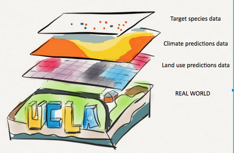
Geographic Information Systems, or GIS, utilizes the power of mapping to show data in a comprehensive way It is used to display information in a visually meaningful way, and allows us to analyze patterns and trends using an easily communicable method--a map. A Geographic Information System can provide us with the necessary analysis to make geographically influenced decisions. GIS has been used in this project to display the distribution of biodiversity over space and time.
Why is Biodiversity relevant to me?
The biodiversity of the planet is being threatened by an undetermined amount of nearly certain temperature increase. We must accommodate the needs of biodiversity, because without it, we wouldn't have fresh water, food, air, medicine, and a number of other ecosystem services that allow us to survive on Earth.
Collins, M., R. Knutti, J. Arblaster, J. L. Dufresne, T. Fichefet, P. Friedlingstein, X. Gao, W.J. Gutowski, T. Johns, G. Krinner, M. Shongwe, C. Tebaldi, A.J. Weaver and M. Wehner, 2013: Long-term Climate Change: Projections, Commitments and Irreversibility. In: Climate Change 2013: The Physical Science Basis. Contribution of Working Group I to the Fifth Assessment Report of the Intergovernmental Panel on Climate Change [Stocker, T.F., D. Qin, G.-K. Plattner, M. Tignor, S.K. Allen, J. Boschung, A. Nauels, Y. Xia, V. Bex and P.M. Midgley (eds.)]. Cambridge University Press, Cambridge, United Kingdom and New York, NY, USA, pp. 1029–1136, doi:10.1017/CBO9781107415324.024.
Riordan, E. C., T.W. Gillespie, L. Pitcher, S.S. Pincetl, G.D. Jenerette, D.E. Pataki. Threats of future climate change and land use to vulnerable tree species native to Southern California. Environmental Conservation. 1-12 (2014).
Zeunert, J. Challenging assumptions in urban restoration ecology. Landscape Journal: Design, planning, and management of the land, 32, 231-242 (2013).
